(CNN) – Tornadoes are one of the most violent forces of nature on Earth. They have been produced in all 50 states of the United States and have been seen throughout the year. Although they are more common in the United States, tornadoes can occur all over the world.
While great strides have been made in the study of tornadoes, there is still much we don’t know about them. In recent decades they have been studied enormously to find out what causes them and how they form.
CNN meteorologist Brandon Miller, who is also a storm chaser, has been tracking and studying storm events since 2005.
“One thing you learn from studying tornadoes, especially on the ground, is that there is no perfect formula for tornado formation – every storm is unique,” says Miller.
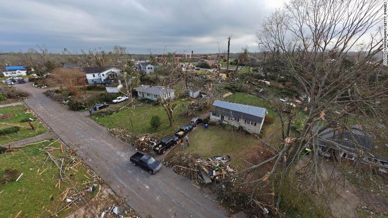
An aerial view from a drone shows the damage to houses caused by a tornado on March 26, 2021, in Newnan, Georgia. An EF-4 category tornado reportedly passed through the region. (Photo: Scott Cunningham / Getty Images)
“Sometimes a storm may appear to be in a perfect environment for a tornado to form, but it never does. In contrast, tornadoes often form in fringe environments where one or more seem to be missing. ‘ ingredients’ for the formation of the storm, “says Miller.
Although there is no perfect formula for knowing which storms will produce tornadoes, there are common elements in the anatomy of the systems that give rise to tornadoes.
There are even signs that you can see that help you understand the life cycle of a developing storm that could produce a tornado.
The development of a thunderstorm
As the hot air rises, the clouds begin to grow higher and higher. This is the development phase of the storm. You can see the fluffy white cumulus clouds grow with your own eyes. This happens before you see the rain or hear the thunder.

As a storm develops, the air rises, helping the cloud grow larger and larger.
As the clouds grow, you will notice that the bottom of the cloud darkens. Many times you will see the top of the cloud flatten out, creating an anvil shape that sticks out of the top of the cloud.
This indicates that there is very cold air at the top of the cloud and could be a precursor to the possibility of hail.
When a storm turns into a supercell
As the storm matures, it could develop into what is known as a supercell. A supercell is a rotating electrical storm.
“Almost all supercells produce some type of severe weather (large hail or damaging winds), but only 30% or less produce tornadoes,” says the National Oceanic and Atmospheric Administration (NOAA).
Cold air coming out of the storm cloud produces a gust front or storm front.
During this maturity phase of the storm or supercell, heavy rains, lightning, hail, and very strong winds are expected.
Sometimes a strong gust of wind will be felt a few moments before the rain comes. This is called the gust front. The cause is the cold air that descends from the storm cloud. When cold air hits the ground, it spreads quickly, anticipating the storm. This is a sure sign that a storm is near.
Formation of a tornado
Tornadoes often form from supercells. These supercells develop when there are several ingredients that help them thrive: instability, lift, and wind shear.
Inside the supercell, wind shear becomes a crucial component for the development of storms. Shear occurs when winds change direction with height. This creates a twist within the thunderstorm cloud.
Another force acting within the supercell is a downdraft. This is an area of drier air that is pushed down from the storm. When pushed down, it engulfs the rear of the storm.
The updrafts and downdrafts work together to pull the horizontal column of air downward and form the tornado. This vertical column of air is called a funnel cloud until it hits the ground, at which point it becomes a tornado.
The most telling sign that a tornado is forming, when observing a severe thunderstorm up close, is the ‘wall cloud‘”says Miller.
The wall cloud is a descent from the base of the cloud that will give rise to the vortex, or spin of the air.
When this rotating column of air hits the ground, a tornado has formed.
The presence of a wall cloud does not always mean a tornado is going to form, but it certainly increases the odds. “You will know that you are looking at a wall cloud because it will be noticeably lower than the rest of the storm and you will be able to tell that it is rotating if you look closely at it,” says Miller.
Tornadoes have produced the strongest winds ever recorded on Earth
Most tornadoes are relatively small and short-lived, yet they can still be dangerous and cause damage. However, the most violent tornadoes can be more than a mile wide and stay on the ground for more than an hour. This is because they have much more momentum than smaller tornadoes, making them more difficult to stop.
A tornado makes its way through a field in Minneola, Kansas, on May 24, 2016.
Miller has witnessed between 15 and 20 tornadoes during his years of storm chasing.
“There is no denying that there is a certain amount of excitement that comes from watching a tornado when you set out with the intention of seeing one,” says Miller.
“At the same time, you balance that excitement with a considerable amount of anxiety and concern about what the tornado might do, especially if there are residents in the immediate path of the storm. As someone who has spent years studying, and many more years reporting About tornadoes, my nerves still get shot when you see a tornado in person. “
Chealsea Zuchnic, 3, walks past the wreckage of a truck wrapped in a tree in front of the destroyed Zuchnic home in Bridge Creek, Oklahoma, on May 4, 1999.
The smallest tornadoes have winds of 96 to 177 km / h, while the most violent can have winds of 257 to more than 322 km / h.
The strongest winds ever recorded on Earth were those of a tornado, on May 3, 1999, at Bridge Creek, Oklahoma, with more than 482 km / h.
CNN’s Jackson Dill and CNN meteorologist Haley Brink contributed to this report.
https://wakelet.com/wake/JEpdSxm0Q9nDFO3NaDV6H
https://wakelet.com/wake/LSRXZ8slnBWsidtaG1NWj
https://wakelet.com/wake/3r6n0JIunFXLwwnkMLXHj
https://wakelet.com/wake/zQJrDp-zAdbGXCjvsYnlA
https://wakelet.com/wake/JvKLqsI0eMDEJdtwKEQce
https://wakelet.com/wake/4Fk0sDP6idYEUkY5AIWU-
https://wakelet.com/wake/3P6ctZJNqkIMnANC71Zbx
https://wakelet.com/wake/ejwsmjk0baK8cXG4a34z1
https://wakelet.com/wake/JYAluWGB5_qAF0gO_f9UA
https://peatix.com/user/8875638
https://wakelet.com/wake/_YGBPNQU0i4o6MKnFUopH
https://wakelet.com/wake/W_oje8-I-2O8MDLIxJMTn
https://wakelet.com/wake/tC3BeS5KlF8k2WL75SaJD
https://wakelet.com/wake/UhOAMOdWSBqK-AjF6B2ek
https://wakelet.com/wake/ltv-J-i6uJlJOP-csUv92
https://wakelet.com/wake/WkIyTR5LS_1l_1kxjENQk
https://wakelet.com/wake/7gpDzoRS1P_TMrKsO3QCQ
https://wakelet.com/wake/c6_U3cIDWkfoCQzUItOIl
https://peatix.com/user/9064678
https://wakelet.com/wake/4oiHCULgkyxJa46AAAo79
https://wakelet.com/wake/NuSzM2RkzghhL4S2VzlYg
https://wakelet.com/wake/NTjJr-ZKZKY8ExQxT07jH
https://wakelet.com/wake/nv_ix-Fxdkp-u_afauiKY
https://wakelet.com/wake/CT13RW8mXmZdcqSpSu7ur
https://wakelet.com/wake/DIX0zKLBg6-Ezb-BJVYSR